Construction Industry Solutions
UAVCTECH provides comprehensive drone services that revolutionize construction workflows, from planning to completion. Our solutions enhance efficiency, improve safety, and reduce costs.
Key Applications
- Site surveying and mapping with centimeter accuracy
- Progress monitoring and documentation with automated flight paths
- Stockpile volume measurements for inventory management
- Safety inspections and compliance documentation
- Infrastructure monitoring for bridges and large structures
- 3D modeling and BIM integration for project visualization
Benefits
- Reduce surveying time by up to 80% compared to traditional methods
- Improve worksite safety by minimizing human exposure to hazardous areas
- Enhance project accuracy with high-resolution data collection
- Save costs through efficient monitoring and reduced rework
- Streamline communication with stakeholders through visual documentation
Industry Impact
100%
Projects Completed On Time
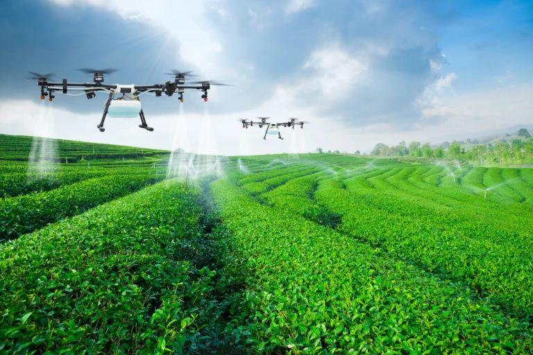
Agriculture Industry Solutions
Transform farming practices with our precision agriculture drone services. Maximize yields, reduce resource usage, and make data-driven decisions for your agricultural operations.
Key Applications
- Crop health monitoring with multispectral and hyperspectral imaging
- Precision spraying and application with variable rate technology
- Irrigation planning and management through moisture mapping
- Yield prediction and estimation for better harvest planning
- Field mapping and soil analysis for optimal planting strategies
- Livestock monitoring and management across large areas
- Plant counting and population analysis for crop assessment
Benefits
- Increase crop yields by 15-20% through targeted interventions
- Reduce water usage by up to 30% with precision irrigation
- Minimize chemical usage by 50-60% with targeted application
- Early detection of pests and diseases before visible symptoms appear
- Optimize resource allocation based on precise field data
Industry Impact
85%
Early Problem Detection
Energy Industry Solutions
Enhance the safety and efficiency of energy operations with our specialized drone services for solar, wind, and traditional energy infrastructure. Our solutions minimize downtime and maximize productivity.
Key Applications
- Solar panel inspection and maintenance with thermal imaging
- Wind turbine inspection including blade and tower assessment
- Power line and pipeline monitoring across difficult terrain
- Thermal imaging for fault detection in electrical systems
- Facility security and surveillance for energy infrastructure
- Environmental monitoring and compliance reporting
- Offshore platform inspection reducing need for personnel transfers
Benefits
- Reduce inspection time by 80% compared to traditional methods
- Improve worker safety by minimizing exposure to hazardous environments
- Identify issues early with detailed thermal and visual data
- Minimize downtime through efficient assessment and planning
- Lower operational costs with reduced need for specialized equipment
Real Estate Industry Solutions
Showcase properties in their best light with stunning aerial photography and videography that captures the full scope and context of any real estate asset. Our services help you market properties more effectively and make informed development decisions.
Key Applications
- Aerial property photography for listings and marketing materials
- Cinematic video tours showcasing properties and surroundings
- Site planning and development visualization for new projects
- Property marketing materials including virtual tours and 360° views
- Topographic mapping for land assessment and development planning
- Neighborhood context imaging showing proximity to amenities
- Construction progress documentation for development projects
Benefits
- Increase property views and engagement by up to 400%
- Reduce time on market with more compelling marketing materials
- Showcase unique property features that are only visible from above
- Provide comprehensive context of neighborhood and surroundings
- Make informed development decisions with accurate topographic data
Industry Impact
30%
Higher Perceived Value
75%
Better Development Planning
Public Safety Solutions
Support emergency response and public safety operations with our specialized drone services designed for critical situations. Our technology provides crucial situational awareness when it matters most.
Key Applications
- Search and rescue operations in difficult terrain and conditions
- Disaster assessment and response planning for emergency management
- Law enforcement support for surveillance and operations planning
- Fire monitoring and hot spot detection with thermal imaging
- Crowd monitoring and management for large events
- Incident documentation and reconstruction for investigations
- Hazardous material assessment without exposing personnel to risk
Benefits
- Improve response times by providing rapid aerial assessment
- Enhance situational awareness for better decision-making
- Reduce risk to personnel in dangerous environments
- Document incidents comprehensively for investigation and training
- Cover large areas quickly compared to ground-based operations
Industry Impact
90%
Situational Awareness